 Draw the Border



THE DRAW THE BORDER GUIDE
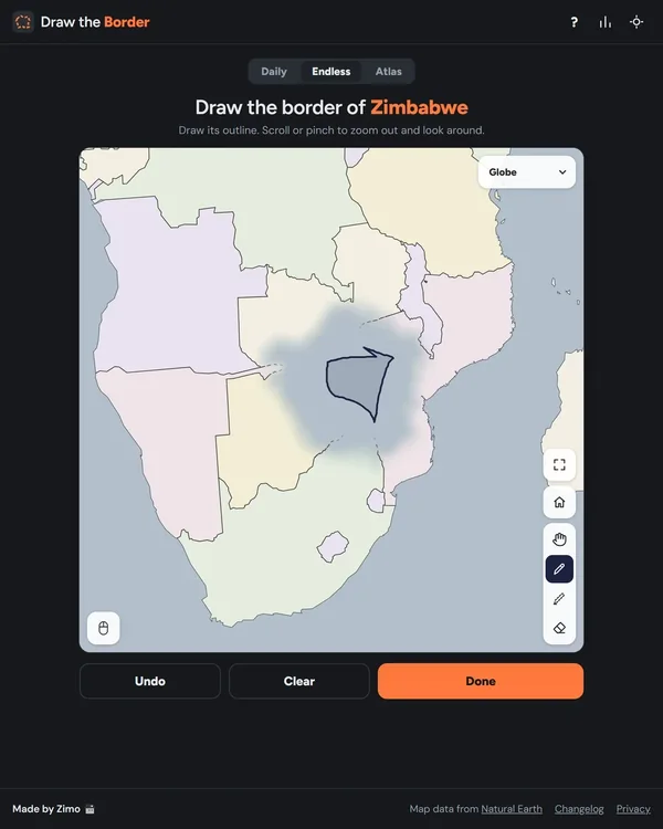
A country is hidden under fog. Reconstruct its outline, submit the drawing and see how its border, overlap, size and shape compare with the real map.
In this guide
Draw the Border at a glance
What is Draw the Border?
Draw the Border is Zimo’s geography drawing game at drawtheborder.com. A country is hidden beneath fog and you recreate its outline from memory on the map. The Daily mode records your first score for the day as the official attempt. Endless supplies more practice, while Atlas builds a larger map from countries you draw one after another. The site credits Natural Earth for its map data.[1][3]
The puzzle is about producing a shape, not selecting a country from a list. You must decide where the outline lies and how its proportions fit the surrounding map. The official changelog also documents occasional featured regions and historic borders, so read the title instead of assuming every round must be a present-day sovereign country.[1][4]
How to draw, correct and submit an outline
Use Pen to draw the scored outline. You can lift the pointer and continue; the game joins the lines and closes open outlines when you press Done. Sketch creates helper lines that are not scored, and Eraser removes mistakes. Undo is available as well. For a country with islands, the official instructions allow more than one shape.[1]
Move and zoom before drawing fine detail. On desktop, the middle mouse button, Ctrl plus drag, or Hand moves the map; the mouse wheel zooms. Keyboard shortcuts include P for Pen, S for Sketch, E for Eraser, H for Hand and F for full screen. On a phone, one finger draws while two fingers move and zoom. Hand also lets you move with one finger.[1]
How the four-part score works
The displayed accuracy score combines four components. Border contributes 65 percent and measures how closely your line follows the real border where you drew it. Overlap contributes 10 percent for covering the same ground. Size contributes 10 percent for the total area. Shape contributes 15 percent for the outline itself, including when its position or size is wrong. Islands are matched individually for the shape component.[1]
That breakdown explains why a familiar-looking outline may not score as strongly as expected. A good shape can still be misplaced, oversized or poorly aligned along the actual border. All countries are displayed at the same size for evaluation, so a small country is not automatically judged more loosely than a large one.[1]
Read the components after submitting instead of judging only the total. If shape is stronger than overlap and size, work on placement and proportions. If the overall footprint looks plausible but border accuracy is weak, refine major bends rather than adding decorative detail. This is a way to learn from the published components, not a guarantee about any one drawing’s score.
A practical map-drawing strategy
Before the first line, identify a few anchors: a long coast, a narrow peninsula, a major corner or a distinctive border bend. Sketch those relationships lightly if helpful, then build the outline around them. Keep height and width in proportion. A small number of correctly placed landmarks usually gives a better starting structure than tracing an uncertain coastline in one fast stroke.
For islands, decide which shapes matter before submitting. The game explicitly supports several separate shapes, so do not join detached islands with a long bridge of land. Use the map controls to check the drawing at a useful scale. If you zoom in closely for one detail, zoom back out to inspect whether the full country still has sensible proportions.
Daily mode, Endless practice and Atlas
Your first score for the Daily puzzle is the official one. The interface labels subsequent attempts as practice, while Endless offers as many countries as you want. Do not use the answer-peek feature or repeated practice attempts as if they were an unassisted first daily score. The game’s own countdown is the clearest guide to the next country; an exact reset timezone was not published in the instructions reviewed here.[1][2]
Atlas turns separate drawings into a larger geographical project. The official changelog describes continent and world selections, choosing countries in any order, persistent sketch lines, a final comparison with the real map, and regional leaderboards. It also documents a United States option covering the contiguous 48 states. Check the selected Atlas region before comparing a completed map with someone else’s.[3][4]
Draw the Border FAQ
Can I draw separate islands in Draw the Border?
Yes. The official instructions say to draw more than one shape for islands, and the shape score matches islands individually.[1]
Which part of the score matters most?
Border contributes 65 percent. Overlap and size each contribute 10 percent, while shape contributes 15 percent.[1]
Can I play more than once a day?
Yes. The first Daily score is official, later Daily attempts are practice, and Endless offers unlimited additional countries.[1][2]
How do I move the map on my phone?
Use two fingers to move and zoom, or select Hand to move with one finger. One finger with the drawing tool makes a stroke.[1]
Sources & verification
Checked · Daily Games editorial desk
- Draw the Border — official game and complete how-to-play dialog drawtheborder.com
- Draw the Border — official Endless practice mode drawtheborder.com
- Draw the Border — official Atlas mode drawtheborder.com
- Draw the Border — official dated changes, modes and scoring updates drawtheborder.com
Rules and access notes use the sources linked above. Examples and strategy suggestions are our editorial explanations, not guaranteed solutions. Original games can change. How we research guides.
Did this guide help?
Help us keep Draw the Border useful and accurate.